 |
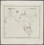
| Ragged island harbour : surveyed by commr. R. Owen 1834 |
|
| Creator: | |
J&C Walker
Hydrographic Office of the Admiralty
|
| Publisher: | | Hydrographic Office of the Admiralty ( London ) |
| Publication Date: | | 1843 |
| Type: | | Map |
| Format: | | 1 map : engraving ; 24,5x28 cm. |
| Source Institution: | | Universiteit Leiden |
| Subject Keyword: | |
Caribisch gebied
Bahama's
Havens
Kaarten (vorm)
|
| Spatial Coverage: | |
Caribisch gebied
Bahama's
Havens
|
| Genre: | | Kaarten (vorm) (gtt) |
| Language: | | English |
|
| Ragged island harbour : surveyed by commr. R. Owen 1834 |
|
 |
| West Indies Sheet IX from Los Roques to Cabo la Vela : Chiefly from Spanish documents |
|
| Creator: | | Walker, J.&C |
| Publisher: | | Hydrographic Office of the Admiralty ( London ) |
| Publication Date: | | [1879] |
| Type: | | Map |
| Format: | | 1 map : etching/opper engraving ; 50 x 65 cm. |
| Source Institution: | | Universiteit Leiden |
| Subject Keyword: | |
Venezuela
Nederlandse Antillen
Willemstad (Curaçao)
|
| Spatial Coverage: | |
Venezuela
Nederlandse Antillen
Willemstad (Curaçao)
|
| Language: | | English |
|
| West Indies Sheet IX from Los Roques to Cabo la Vela : Chiefly from Spanish documents |
|
|
|
