|
|
| |
|
|
|
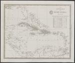 |
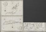
| The Antilles or West India Islands |
|
| Creator: | | Baldwin & Cradock ( London) |
| Publisher: | | Baldwin & Cradock ( London ) |
| Publication Date: | | 1835 |
| Type: | | Map |
| Format: | | 1 map : lithography ; 31,5x38,5 cm. |
| Source Institution: | | Universiteit Leiden |
| Subject Keyword: | |
Caribisch gebied
Kaarten (vorm)
|
| Spatial Coverage: | | Caribisch gebied |
| Genre: | | Kaarten (vorm) (gtt) |
| Language: | | English |
|
| The Antilles or West India Islands |
|
 |
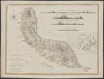
| A chart of the colony of Surinam, on the coast of Guyana |
|
| Creator: | |
Wilkinson, Robert
C.G. Player (Lewisham)
|
| Publisher: | |
C.G. Player ( Lewisham )
Wilkinson ( London )
|
| Publication Date: | | 1800 |
| Type: | | Map |
| Format: | | 1 map in 4 sheets : copper gravure ; each sheet 61,5x56 cm. |
| Source Institution: | | Universiteit Leiden |
| Subject Keyword: | |
Suriname (land)
Plantages
Kaarten (geografie)
|
| Spatial Coverage: | |
Suriname (land)
Plantages
|
| Genre: | | Kaarten (geografie) (gtt) |
| Language: | | English |
|
| A chart of the colony of Surinam, on the coast of Guyana |
|
 |
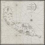
| Curaçao, from the Dutch originals of Gerard van Keulen : regulated by astronomical observations |
|
| Creator: | |
Keulen, Gerard van
Laurie & Whittle (London)
|
| Publisher: | | Laurie & Whittle ( London ) |
| Publication Date: | | 1794 |
| Type: | | Map |
| Format: | | 1 map : colour ; 46,5x61,5 cm. |
| Source Institution: | | Universiteit Leiden |
| Subject Keyword: | |
Curaçao
Kaarten (geografie)
|
| Spatial Coverage: | | Curaçao |
| Genre: | | Kaarten (geografie) (gtt) |
| Language: | | English |
|
| Curaçao, from the Dutch originals of Gerard van Keulen : regulated by astronomical observations |
|
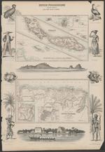 |
| Curaçao on an enlarged scale |
|
| Creator: | |
Dunlop, J
A.Fullerton & Co. (London;Edinburgh)
|
| Publisher: | | A. Fullarton & Co. ( London ;, Edinburgh ) |
| Publication Date: | | [ca. 1861] |
| Type: | | Map |
| Format: | | 1 krt. : staalgravure, gekleurd. ; 14,5×23 cm. |
| Source Institution: | | Universiteit Leiden |
| Language: | | English |
|
| Curaçao on an enlarged scale |
|
|
 |
| The island of Becouya |
|
| Creator: | |
Heather, William, 1790-1812 fl
Stephenson, J, ca1780-ca1830 fl
|
| Publisher: | | Heather ( London ) |
| Publication Date: | | 1808 |
| Type: | | Map |
| Format: | | 5 maps in 1 sheet : copper gravure ; sheet 64x93 cm. |
| Source Institution: | | Universiteit Leiden |
| Subject Keyword: | |
Kleine Antillen
Caribisch gebied
Kaarten (vorm)
|
| Spatial Coverage: | |
Kleine Antillen
Caribisch gebied
|
| Genre: | | Kaarten (vorm) (gtt) |
| Language: | | English |
|
| The island of Becouya |
|
 |
| The island of Curacao |
|
| Creator: | |
Heather, William, 1790-1812 fl
Stephenson, J, ca1780-ca1830 fl
|
| Publisher: | | Heather ( London ) |
| Publication Date: | | 1808 |
| Type: | | Map |
| Format: | | 1 map : copper gravure ; 46x46 cm. |
| Source Institution: | | Universiteit Leiden |
| Language: | | English |
|
| The island of Curacao |
|
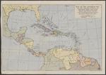 |
| Map of the Caribbean, etc., and other territories covered by the "The West Indies Year Book", showing their relative positions |
|
| Publisher: | | Geographia Ltd. ( London ) |
| Publication Date: | | [20th century] |
| Type: | | Map |
| Format: | | 1 map : colour print ; 35 x 49 cm. |
| Source Institution: | | Universiteit Leiden |
| Subject Keyword: | | Midden-Amerika |
| Spatial Coverage: | | Midden-Amerika |
| Language: | | English |
|
| Map of the Caribbean, etc., and other territories covered by the "The West Indies Year Book", showing their relative positions |
|
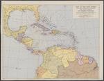 |
| Map of the West Indies and other territories covered by "The West Indies Year Book" |
|
| Publisher: | | Geographia Ltd. ( London ) |
| Publication Date: | | [20th century] |
| Type: | | Map |
| Format: | | 1 map : colour print ; 38 x 49 cm. |
| Source Institution: | | Universiteit Leiden |
| Subject Keyword: | | Midden-Amerika |
| Spatial Coverage: | | Midden-Amerika |
| Language: | | English |
|
| Map of the West Indies and other territories covered by "The West Indies Year Book" |
|
|
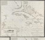 |
| A new and accurate Mercators chart of the Bay of Honduras, Mosquito Shore and the British Yucatan, also the Bahama Islands : including Jamaica, Cuba, Hispaniola, part of East Florida &c |
|
| Creator: | | Steel, D |
| Publisher: | | D. Steel ( London ) |
| Publication Date: | | 1800 |
| Type: | | Map |
| Format: | | 1 map : copper gravure ; 107x120 cm. |
| Source Institution: | | Universiteit Leiden |
| Subject Keyword: | |
Caribisch gebied
Kaarten (vorm)
|
| Spatial Coverage: | | Caribisch gebied |
| Genre: | | Kaarten (vorm) (gtt) |
| Language: | | English |
|
| A new and accurate Mercators chart of the Bay of Honduras, Mosquito Shore and the British Yucatan, also the Bahama Islands : including Jamaica, Cuba, Hispaniola, part of East Florida &c |
|
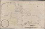 |
| A new and correct general chart of the West Indies including the Gulf of Mexico & Bay of Honduras &c. : collected from the Journals Surveys and Astronomical Observations, of the most celebrated navigators |
|
| Creator: | | Heather, William |
| Publisher: | | by William Heather ( London ) |
| Publication Date: | | 1811 |
| Type: | | Map |
| Format: | | 1 map : copper gravure ; 77x123,5 cm. |
| Source Institution: | | Universiteit Leiden |
| Subject Keyword: | |
Caribisch gebied
Kaarten (vorm)
|
| Spatial Coverage: | | Caribisch gebied |
| Genre: | | Kaarten (vorm) (gtt) |
| Language: | | English |
|
| A new and correct general chart of the West Indies including the Gulf of Mexico & Bay of Honduras &c. : collected from the Journals Surveys and Astronomical Observations, of the most celebrated navigators |
|
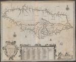 |
| Novissima et accuratissima Jamaicae Descriptio |
|
| Creator: | | Ogilby, John, 1600-1676 |
| Publication Date: | | 1671 |
| Type: | | Map |
| Format: | | 1 map : engraving ; 43,5×54 cm. |
| Source Institution: | | Universiteit Leiden |
| Subject Keyword: | |
Jamaica
Caribisch gebied
Kaarten (vorm)
|
| Spatial Coverage: | |
Jamaica
Caribisch gebied
|
| Genre: | | Kaarten (vorm) (gtt) |
| Language: | | Latin |
|
| Novissima et accuratissima Jamaicae Descriptio |
|
 |
| Plano de la Ciudad de Kingston en la Jamaica : Segun el proyecto del Coronel Christian Lilly ... |
|
| Creator: | | Lopez, Don Juan |
| Publication Date: | | 1782 |
| Type: | | Map |
| Format: | | 4 maps in 1 sheet : engraving, color ; Sheet 39×40,5 cm. |
| Source Institution: | | Universiteit Leiden |
| Subject Keyword: | |
Jamaica
Caribisch gebied
Kaarten (vorm)
|
| Spatial Coverage: | |
Jamaica
Caribisch gebied
|
| Genre: | | Kaarten (vorm) (gtt) |
| Language: | | Spanish |
|
| Plano de la Ciudad de Kingston en la Jamaica : Segun el proyecto del Coronel Christian Lilly ... |
|
|
 |
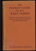
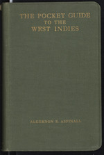
| The pocket guide to the West Indies : British Guiana, British Honduras, Bermuda, The Spanish Main, Surinam and the Panama Canal |
|
| Creator: | | Aspinall, Algernon Edward, 1871-1952 |
| Publication Date: | | [1939] |
| Type: | | Book |
| Format: | | XVI, 525 p. : ill. ; 17 cm. |
| Edition: | | [New and rev. ed.] |
| Source Institution: | | Leiden University |
| Subject Keyword: | |
Guidebooks -- West Indies
Guidebooks -- Guyana
Guidebooks -- Bermuda Islands
Guidebooks -- Spanish Main
Guidebooks -- Panama Canal (Panama)
|
| Spatial Coverage: | |
West Indies
Guyana
Bermuda Islands
Spanish Main
Panama Canal (Panama)
|
| Genre: | | non-fiction (marcgt) |
| Language: | | English |
|
| The pocket guide to the West Indies : British Guiana, British Honduras, Bermuda, The Spanish Main, Surinam and the Panama Canal |
|
 |
| The pocket guide to the West Indies : British Guiana, British Honduras, the Bermudas, the Spanish Main and the Panama canal |
|
| Creator: | | Aspinall, Algernon Edward, 1871-1952 |
| Publication Date: | | 1923 |
| Type: | | Book |
| Format: | | X, 479 p. : ill. ; 18 cm. |
| Edition: | | [new and rev. ed.] |
| Source Institution: | | Leiden University |
| Subject Keyword: | | Guidebooks -- West Indies |
| Spatial Coverage: | | West Indies |
| Genre: | | non-fiction (marcgt) |
| Language: | | English |
|
| The pocket guide to the West Indies : British Guiana, British Honduras, the Bermudas, the Spanish Main and the Panama canal |
|
 |
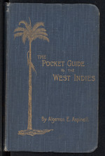
| The pocket guide to the West Indies |
|
| Creator: | | Aspinall, Algernon Edward, 1871-1952 |
| Publisher: | | Duckworth ( London ) |
| Publication Date: | | 1910 |
| Type: | | Book |
| Format: | | XVI, 317 p. : ill. ; 18 cm. |
| Edition: | | New and rev. ed. |
| Source Institution: | | Leiden University |
| Subject Keyword: | | Guidebooks -- West Indies |
| Spatial Coverage: | | West Indies |
| Genre: | | non-fiction (marcgt) |
| Language: | | English |
|
| The pocket guide to the West Indies |
|
 |
| The pocket guide to the West Indies |
|
| Creator: | | Aspinall, Algernon Edward, 1871-1952 |
| Publisher: | | Stanford ( London ) |
| Publication Date: | | 1907 |
| Type: | | Book |
| Format: | | XX, 316 p. : ill. ; 18 cm. |
| Source Institution: | | Leiden University |
| Subject Keyword: | | Guidebooks -- West Indies |
| Spatial Coverage: | | West Indies |
| Genre: | | non-fiction (marcgt) |
| Language: | | English |
|
| The pocket guide to the West Indies |
|
|
 |
| The pocket guide to the West Indies and British Guiana, British Honduras, Bermuda, The Spanish Main, Surinam, the Panama Canal |
|
| Creator: | |
Aspinall, Algernon Edward, 1871-1952
Dash, J. Sydney
|
| Publisher: | | Methuen ( London ) |
| Publication Date: | | [1954] |
| Type: | | Book |
| Format: | | XX, 475, 22 p. : ill. ; 17 cm. |
| Edition: | | 10th ed., rev. and reset -- rev. by J. Sydney Dash. |
| Source Institution: | | Leiden University |
| Subject Keyword: | |
Guidebooks -- West Indies
Guidebooks -- Guyana
Guidebooks -- Belize
Guidebooks -- Bermuda Islands
Guidebooks -- Canal Zone
|
| Spatial Coverage: | |
West Indies
Guyana
Belize
Bermuda Islands
Canal Zone
|
| Genre: | | non-fiction (marcgt) |
| Language: | | English |
|
| The pocket guide to the West Indies and British Guiana, British Honduras, Bermuda, The Spanish Main, Surinam, the Panama Canal |
|
 |
| The pocket guide to the West-Indies, British Guiana, British Honduras, Bermuda, the Spanish Main, Surinam and the Panama canal |
|
| Creator: | | Aspinall, Algernon Edward, 1871-1952 |
| Publisher: | | Sifton, Spraed & Co ( London ) |
| Publication Date: | | 1931 |
| Type: | | Book |
| Format: | | XIV, 500 p. : ill. ; 17 cm. |
| Edition: | | New and rev. ed. |
| Source Institution: | | Leiden University |
| Subject Keyword: | | Guidebooks -- Suriname |
| Spatial Coverage: | | Suriname |
| Genre: | | non-fiction (marcgt) |
| Language: | | English |
|
| The pocket guide to the West-Indies, British Guiana, British Honduras, Bermuda, the Spanish Main, Surinam and the Panama canal |
|
 |
| The pocket guide to the West-Indies, British Guiana, British Honduras, the Bermudas, the Spanish Main and the Panama canal |
|
| Creator: | | Aspinall, Algernon Edward, 1871-1952 |
| Publisher: | | Sifton, Spraed & Co ( London ) |
| Publication Date: | | 1927 |
| Type: | | Book |
| Format: | | XIV, 493, XXIV p. : ill. ; 18 cm. |
| Source Institution: | | Leiden University |
| Subject Keyword: | | Guidebooks -- West Indies |
| Spatial Coverage: | | West Indies |
| Genre: | | non-fiction (marcgt) |
| Language: | | English |
|
| The pocket guide to the West-Indies, British Guiana, British Honduras, the Bermudas, the Spanish Main and the Panama canal |
|
![Punta San Juan to Cabo San Roman, including Islas de Aves to Aruba : from the United States and the Netherlands Gov[ernment] charts to 1952](https://dcdp.uoc.cw/content/AA/00/00/31/79/00001/NL-0200050000_UBL10_04175thm.jpg) |
| Punta San Juan to Cabo San Roman, including Islas de Aves to Aruba : from the United States and the Netherlands Gov[ernment] charts to 1952 |
|
| Publication Date: | | 1953 |
| Type: | | Map |
| Format: | | 1 kaart. : ; 67 x 100 cm. |
| Source Institution: | | Universiteit Leiden |
| Language: | | English |
|
| Punta San Juan to Cabo San Roman, including Islas de Aves to Aruba : from the United States and the Netherlands Gov[ernment] charts to 1952 |
|
|
