|
|
| |
|
|
|
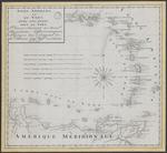 |
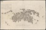
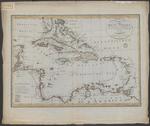
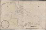
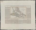
| Isles Antilles ou du Vent avec les Isles sous le vent : placées suivant les nouv.les observations astronomiques, redigées sur l'original de Mr. Bonne... |
|
| Publication Date: | | 1794 |
| Type: | | Map |
| Format: | | 1 krt. : manuscript, gekleurd. ; 41,5×45 cm. |
| Source Institution: | | Universiteit Leiden |
| Subject Keyword: | | Kleine Antillen |
| Spatial Coverage: | | Kleine Antillen |
| Language: | | French |
|
| Isles Antilles ou du Vent avec les Isles sous le vent : placées suivant les nouv.les observations astronomiques, redigées sur l'original de Mr. Bonne... |
|
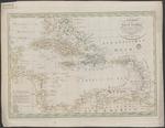 |
| Charte von West Indien nach der grossen Charte des B. Edwards, Esqr. und andern zuverlassigne Hulfsmitteln neu entworfen von F.L. Gussefeld |
|
| Creator: | | Güssefeld, Franz Ludwig, 1744-1807 |
| Publisher: | | im Verlag des Industrie Comptoirs ( Weimar ) |
| Publication Date: | | 1795 |
| Type: | | Map |
| Format: | | 1 map : copper gravure, color ; 43,5 x61,5 cm. |
| Source Institution: | | Universiteit Leiden |
| Subject Keyword: | |
Caribisch gebied
Kaarten (vorm)
|
| Spatial Coverage: | | Caribisch gebied |
| Genre: | | Kaarten (vorm) (gtt) |
| Language: | | German |
|
| Charte von West Indien nach der grossen Charte des B. Edwards, Esqr. und andern zuverlassigne Hulfsmitteln neu entworfen von F.L. Gussefeld |
|
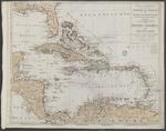 |
| Tabula Geographica Maximae Partis Americae Mediae sive Indiae Occidentalis : Karte des betraechtlichsten Theils von Mittel-America oder Westindien |
|
| Creator: | | Walch, Johann |
| Publisher: | | bey Johanes Walch ( Augsburg ) |
| Publication Date: | | 1798 |
| Type: | | Map |
| Format: | | 1 map : copper gravure, color ; 49x60 cm. |
| Source Institution: | | Universiteit Leiden |
| Subject Keyword: | |
Caribisch gebied
Kaarten (vorm)
|
| Spatial Coverage: | | Caribisch gebied |
| Genre: | | Kaarten (vorm) (gtt) |
| Language: | | German |
|
| Tabula Geographica Maximae Partis Americae Mediae sive Indiae Occidentalis : Karte des betraechtlichsten Theils von Mittel-America oder Westindien |
|
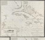 |
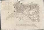
| A new and accurate Mercators chart of the Bay of Honduras, Mosquito Shore and the British Yucatan, also the Bahama Islands : including Jamaica, Cuba, Hispaniola, part of East Florida &c |
|
| Creator: | | Steel, D |
| Publisher: | | D. Steel ( London ) |
| Publication Date: | | 1800 |
| Type: | | Map |
| Format: | | 1 map : copper gravure ; 107x120 cm. |
| Source Institution: | | Universiteit Leiden |
| Subject Keyword: | |
Caribisch gebied
Kaarten (vorm)
|
| Spatial Coverage: | | Caribisch gebied |
| Genre: | | Kaarten (vorm) (gtt) |
| Language: | | English |
|
| A new and accurate Mercators chart of the Bay of Honduras, Mosquito Shore and the British Yucatan, also the Bahama Islands : including Jamaica, Cuba, Hispaniola, part of East Florida &c |
|
|
 |
| A chart of the colony of Surinam, on the coast of Guyana |
|
| Creator: | |
Wilkinson, Robert
C.G. Player (Lewisham)
|
| Publisher: | |
C.G. Player ( Lewisham )
Wilkinson ( London )
|
| Publication Date: | | 1800 |
| Type: | | Map |
| Format: | | 1 map in 4 sheets : copper gravure ; each sheet 61,5x56 cm. |
| Source Institution: | | Universiteit Leiden |
| Subject Keyword: | |
Suriname (land)
Plantages
Kaarten (geografie)
|
| Spatial Coverage: | |
Suriname (land)
Plantages
|
| Genre: | | Kaarten (geografie) (gtt) |
| Language: | | English |
|
| A chart of the colony of Surinam, on the coast of Guyana |
|
 |
| Charte over den Danske Oe St. Jan i America Optaget i Aaret 1780, og ugdiveti Aaret 1800 |
|
| Creator: | | Oxholm, Peter Lotharius |
| Publisher: | | G.N. Angelo ( Kobenhavn ) |
| Publication Date: | | 1800 |
| Type: | | Map |
| Format: | | 1 map : engraving ; 59,5 x 100 cm. |
| Source Institution: | | Universiteit Leiden |
| Subject Keyword: | |
Caribisch gebied
Virgin Islands
Kaarten (vorm)
|
| Spatial Coverage: | |
Caribisch gebied
Virgin Islands
|
| Genre: | | Kaarten (vorm) (gtt) |
| Language: | | Danish |
|
| Charte over den Danske Oe St. Jan i America Optaget i Aaret 1780, og ugdiveti Aaret 1800 |
|
 |
| Charte over den Danske Oe St Croix i America |
|
| Creator: | | Oxholm, Peter Lotharius |
| Publisher: | | G.N. Angelo ( Kobenhavn ) |
| Publication Date: | | 1800 |
| Type: | | Map |
| Format: | | 1 map in 2 sheets : engraving ; 66 x 200 cm. |
| Source Institution: | | Universiteit Leiden |
| Subject Keyword: | |
Caribisch gebied
Virgin Islands
Kaarten (vorm)
|
| Spatial Coverage: | |
Caribisch gebied
Virgin Islands
|
| Genre: | | Kaarten (vorm) (gtt) |
| Language: | | Danish |
|
| Charte over den Danske Oe St Croix i America |
|
 |
| The West-India atlas; or, A compendious description of the West-Indies : consisting of a complete collection of accurate charts, ... forming the whole navigation and distinct maps of the different islands, taken from actual surveys : together with an historical account ... |
|
| Creator: | | Jefferys, Thomas, -1771 |
| Publication Date: | | 1802 |
| Type: | | Book |
| Format: | | iv, 28 p. : ill. ; 54 cm. |
| Edition: | | [New ed.,] -- improved from the latest discoveries. 64 charts, maps and plans. |
| Source Institution: | | Universiteit Leiden |
| Genre: | | non-fiction (marcgt) |
| Language: | | English |
|
| The West-India atlas; or, A compendious description of the West-Indies : consisting of a complete collection of accurate charts, ... forming the whole navigation and distinct maps of the different islands, taken from actual surveys : together with an historical account ... |
|
|
 |
| Charte von West Indien : nach Edwards, De la Rochette und den neuesten astronomischen Beobachtungen entworfen |
|
| Creator: | | Güssefeld, Franz Ludwig, 1744-1807 |
| Publisher: | | Geografisches Institut ( Weimar ) |
| Publication Date: | | 1804 |
| Type: | | Map |
| Format: | | 1 krt. : kopergravure. ; 43x60,5 cm, blad 68x57 cm. |
| Source Institution: | | Universiteit Leiden |
| Subject Keyword: | |
Caribisch gebied
Kaarten (vorm)
|
| Spatial Coverage: | | Caribisch gebied |
| Genre: | | Kaarten (vorm) (gtt) |
| Language: | | German |
|
| Charte von West Indien : nach Edwards, De la Rochette und den neuesten astronomischen Beobachtungen entworfen |
|
 |
| Reize naar de Caribische Eilanden, in de jaren 1780 en 1781 : aan boord van s'Lands schip van oorlog Mars onder bevel van den schout bij nacht Willem Krul |
|
| Creator: | |
Jong, Cornelis de, 1762-1838
Bohn, François (Haarlem)
|
| Publisher: | | bij François Bohn ( Te Haarlem ) |
| Publication Date: | | 1807 |
| Type: | | Book |
| Format: | | X, 326 p., 1 uitsl. ill. : ill. ; 22 cm. |
| Source Institution: | | Leiden University |
| Genre: | | non-fiction (marcgt) |
| Language: | | Dutch |
|
| Reize naar de Caribische Eilanden, in de jaren 1780 en 1781 : aan boord van s'Lands schip van oorlog Mars onder bevel van den schout bij nacht Willem Krul |
|
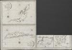 |
| The island of Becouya |
|
| Creator: | |
Heather, William, 1790-1812 fl
Stephenson, J, ca1780-ca1830 fl
|
| Publisher: | | Heather ( London ) |
| Publication Date: | | 1808 |
| Type: | | Map |
| Format: | | 5 maps in 1 sheet : copper gravure ; sheet 64x93 cm. |
| Source Institution: | | Universiteit Leiden |
| Subject Keyword: | |
Kleine Antillen
Caribisch gebied
Kaarten (vorm)
|
| Spatial Coverage: | |
Kleine Antillen
Caribisch gebied
|
| Genre: | | Kaarten (vorm) (gtt) |
| Language: | | English |
|
| The island of Becouya |
|
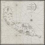 |
| The island of Curacao |
|
| Creator: | |
Heather, William, 1790-1812 fl
Stephenson, J, ca1780-ca1830 fl
|
| Publisher: | | Heather ( London ) |
| Publication Date: | | 1808 |
| Type: | | Map |
| Format: | | 1 map : copper gravure ; 46x46 cm. |
| Source Institution: | | Universiteit Leiden |
| Language: | | English |
|
| The island of Curacao |
|
|
 |
| A new and correct general chart of the West Indies including the Gulf of Mexico & Bay of Honduras &c. : collected from the Journals Surveys and Astronomical Observations, of the most celebrated navigators |
|
| Creator: | | Heather, William |
| Publisher: | | by William Heather ( London ) |
| Publication Date: | | 1811 |
| Type: | | Map |
| Format: | | 1 map : copper gravure ; 77x123,5 cm. |
| Source Institution: | | Universiteit Leiden |
| Subject Keyword: | |
Caribisch gebied
Kaarten (vorm)
|
| Spatial Coverage: | | Caribisch gebied |
| Genre: | | Kaarten (vorm) (gtt) |
| Language: | | English |
|
| A new and correct general chart of the West Indies including the Gulf of Mexico & Bay of Honduras &c. : collected from the Journals Surveys and Astronomical Observations, of the most celebrated navigators |
|
 |
| Generaele Staat der Bevolking van het eiland Curacao |
|
| Publication Date: | | 1816 |
| Type: | | Book |
| Format: | | 1 stuk. : ; |
| Source Institution: | | Universiteit Leiden |
| Genre: | | non-fiction (marcgt) |
| Language: | | Dutch |
|
| Generaele Staat der Bevolking van het eiland Curacao |
|
 |
| Atlas der overzeesche bezittingen van Zijne Majesteit den Koning der Nederlanden : aan hoogst den zelven aangeboden |
|
| Creator: | |
Bosch, Js. van den
Zeelander, Abraham Lion, 1789-1856
Landegent, ..
Visser, J.C
C. van Baarsel en Zoon
|
| Publisher: | | Gebroeders van Cleef ( 's-Gravenhage ;, Amsterdam ) |
| Publication Date: | | 1818 |
| Type: | | Map |
| Format: | | 1 atlas, in 12 kaartbladen en titelblad. : handgekleurd, losbladig. ; 35 x 50 cm. |
| Source Institution: | | Universiteit Leiden |
| Subject Keyword: | |
Indonesië
Nederlandse Antillen
Suriname (land)
Atlassen (vorm)
|
| Spatial Coverage: | |
Indonesië
Nederlandse Antillen
Suriname (land)
|
| Genre: | |
Atlassen (vorm) (gtt)
single map (marcgt)
|
| Language: | | Dutch |
|
| Atlas der overzeesche bezittingen van Zijne Majesteit den Koning der Nederlanden : aan hoogst den zelven aangeboden |
|
 |
| Beschrijving van het eiland Curaçao en onderhoorige eilanden, uit onderscheidene stukken, bijdragen en opmerkingen opgemaakt |
|
| Creator: | |
bewoner van dat eiland, een
Bohn, erven François (Haarlem)
|
| Publisher: | | Erven F. Bohn ( Haarlem ) |
| Publication Date: | | 1819 |
| Type: | | Book |
| Format: | | 90 p. : Tab. ; 21 cm. |
| Source Institution: | | Leiden University |
| Subject Keyword: | |
1800-1900
Description and travel -- Curaçao (Netherlands Antilles)
Curaçao
|
| Spatial Coverage: | |
Curaçao (Netherlands Antilles)
Curaçao
|
| Genre: | | non-fiction (marcgt) |
| Language: | | Dutch |
|
| Beschrijving van het eiland Curaçao en onderhoorige eilanden, uit onderscheidene stukken, bijdragen en opmerkingen opgemaakt |
|
|
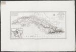 |
| Carte de l'ile de Cuba, redigée sur les observations astronomiques des navigeurs espagnols et sur celles de Mr. de Humboldt |
|
| Creator: | |
Humboldt, Alexander von, 1769-1859
Lapie, Pierre, 1779-1850
|
| Publication Date: | | 1820 |
| Type: | | Map |
| Format: | | 1 kaartblad : ; 31,5 x 64 cm. |
| Source Institution: | | Universiteit Leiden |
| Subject Keyword: | |
Caribisch gebied
Cuba
Kaarten (vorm)
|
| Spatial Coverage: | |
Caribisch gebied
Cuba
|
| Genre: | | Kaarten (vorm) (gtt) |
| Language: | | French |
|
| Carte de l'ile de Cuba, redigée sur les observations astronomiques des navigeurs espagnols et sur celles de Mr. de Humboldt |
|
 |
| Vrolijke tafereelen : aan de vrienden van luim en gezelligheid toegewijd |
|
| Creator: | |
Christemeijer, J.B, 1794-1872
Kesteren, Johannes Christoffel van (Amsterdam)
|
| Publisher: | | J.C. van Kesteren ( Amsterdam ) |
| Publication Date: | | 1822 |
| Type: | | Book |
| Format: | | VIII, 344 p. : ; 22 cm. |
| Source Institution: | | Leiden University |
| Genre: | | non-fiction (marcgt) |
| Language: | | Dutch |
|
| Vrolijke tafereelen : aan de vrienden van luim en gezelligheid toegewijd |
|
 |
| Nieuwe kaart van een gedeelte van de West-Indiën bevattende de Caraibische eilanden Porto Rico, Curaçao, een gedeelte van St.-Domingo en van de noordelijke kust van Zuid-Amerika |
|
| Creator: | | Hulst van Keulen, Weduwe Gerard (Amsterdam) |
| Publisher: | | Hulst van Keulen, Weduwe Gerard ( Amsterdam ) |
| Publication Date: | | 1823 |
| Type: | | Map |
| Format: | | 1 map in 2 sheets : copper gravure ; 99x129 cm. |
| Source Institution: | | Universiteit Leiden |
| Subject Keyword: | |
Suriname (land)
Caribisch gebied
Zeekaarten
|
| Spatial Coverage: | |
Suriname (land)
Caribisch gebied
|
| Genre: | | Zeekaarten. (gtt) |
| Language: | | Dutch |
|
| Nieuwe kaart van een gedeelte van de West-Indiën bevattende de Caraibische eilanden Porto Rico, Curaçao, een gedeelte van St.-Domingo en van de noordelijke kust van Zuid-Amerika |
|
 |
| Geographisch-statistische und historische Charte von Cuba und den Bahama-Inseln |
|
| Publisher: | | Verlag des Geographischen Instituts ( Weimar ) |
| Publication Date: | | 1824 |
| Type: | | Map |
| Format: | | 1 map : engraving, color ; 24x34 cm, sheet 60x72 cm. |
| Source Institution: | | Universiteit Leiden |
| Subject Keyword: | |
Caribisch gebied
Cuba
Bahama's
Kaarten (vorm)
|
| Spatial Coverage: | |
Caribisch gebied
Cuba
Bahama's
|
| Genre: | | Kaarten (vorm) (gtt) |
| Language: | | German |
|
| Geographisch-statistische und historische Charte von Cuba und den Bahama-Inseln |
|
|
